

Research at Birka on Björkö Island in Lake Mälaren has a long tradition. After all, Birka is famous for being one of the key Viking Age trading sites, and UNESCO awarded it World Heritage Site status in 1993.
However, recent research has focused chiefly on the area within the parameters of the city's rampart. That was the case until researchers started utilizing modern technology – such as geo-radars – to help them look at other areas.
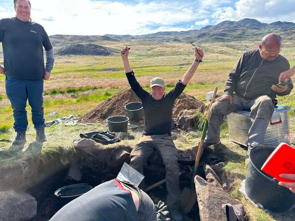
Archaeologists from Stockholm University's Archaeological Research Laboratory Sven Isaksson and Sven Kalmring explored Björkö's northern cape with the help of both modern tools and traditional excavation methods, which enabled them to discover the unique Viking shipyard site.
The Viking Herald reached out to Sven Kalmring, who led the investigations, in an attempt to get a deeper understanding of the importance of the Birka shipyard find.
TVH: Congratulations on the amazing discovery, Sven! Could you tell us more about the excavation project and how new technologies contributed to the discovery?
SK: The Archaeological Research Laboratory, Stockholm University, has been conducting research on Björkö and Birka back and forth since the 1970s, and the current research is a continuation of that. A general aim of the project is to highlight activities going on outside the town rampart of Birka on Björkö. A more specific aim of the last three years of excavation is to document and investigate the maritime cultural landscape in the northern part of Björkö.
This is also the part of the island that faces directly towards the other component of this UNESCO World Heritage site, namely Hovgården on Adelsö with its Royal Manor site. Currently, it is a low-key project, practically running as a field course in Archaeological Science for Master- and PhD-students at the Archaeological Research Laboratory.
Prior to excavations, we applied a multi-elemental geochemical prospection technique in order to aid us in selecting the location of trenches at the site. We also systematically sampled selected contexts for various soil-chemical and macrofossil analyses. The site has a challenging stratigraphy as the anthropogenic remains are affected by both beach processes and slope processes in addition to the ordinary soil formation processes. Investigating the effects of leaching and enrichment processes on elements with varying weathering properties is very helpful in understanding what has been going on in our trenches.
By molecular analyses of soil organic components, we have been able to identify contexts with traces of fir or spruce resins. Connecting this with the finds of whetstones and whetstone fragments made from slate, possibly the traces of the sharpening of woodworking tools, is another example of how we try and integrate new technologies into the archaeological field process. In other contexts, we have found traces of wood tar in the soil organic matrix, another essential component of the upkeep of boats.
On the survey level, we have also applied relatively new technologies, i.e., the use of drones to create Digital Terrain Models and orthophoto maps. The detailed orthophoto map is an excellent supplement to our manual digital mapping, using a Real-Time Kinematic Global Navigation Satellite Systems receiver for the documentation of our field observations.

A digital 3D model of stone packing in one of the investigated trenches. On top of the stone packing was a layer of sand, and originally there was also a wooden boat slip at the bottom. Traces of this can be seen in the form of post-holes and a stone frame at the bottom. Photo: Fredrik Lundstrom
Merging all this data in the GIS software proved to be a robust tool in investigating the visible remains and their relation to the level above the sea. Here the pseudo-coloration of the terrain model proved a useful tool to visualize the Viking Age beach zone on Björkö. As you might know, most parts of Sweden are affected by a post-glacial land upheaval causing the land to consciously rise out of the sea in a complex manner.
This is even more complicated in the body of water where Björkö is situated, today lake Mälaren, but in the Viking Age, a bay or inlet of the Baltic Sea. The complexity comes from the fact that this body of water (Mälaren) has a very large catchment area (more or less the whole of eastern middle Sweden) and very narrow outlets, giving rise to very strong seasonal fluctuations in the water level. This fluctuation is documented from historical times. Today, Mälaren is regulated, and the water level is kept at c. 0.7 meters above sea level.
This is why it is more or less futile to try and define a precise waterline on Björkö during the Viking Age because it was more of a seasonally varying beach zone. By merging the digital terrain model with the distribution of visual remains of jetties and boat landings, we can, e.g., show the close relationship between the distribution and size of these remains and the location of this beach zone.
TVH: In your expert opinion, is it likely that new finds could be discovered along Björkö's northern cape?
SK: Yes, there is a lot to discover still. In May, we conducted Ground Penetrating Radar investigations. We are still analyzing the data, but there is already evidence for previously unknown remains in the area.
Also, of all the maritime remains that we have mapped, we have only investigated one shipyard and one boat landing, and both of these only partially.
There is still much to investigate; have they all been used in the same way, are they all contemporary, etc.

Detailed map of Björkö's northern part, with the results of mapping of near-shore remains between Birka's Black Earth and Korshamn. The features recorded as possible jetty or boat landing remains have a light red fill and are marked 1-9. Photo: Stockholm University
TVH: In your opinion, what is the most interesting aspect or implication of the Viking shipyard find?
SK: Tricky question; it is remarkable in so many ways. But if I need to choose one I would say that its location outside the town rampart is the most interesting aspect. The rampart was not just a fortification but also a legal, economic, and most probably social boundary.
We need to start asking questions like who was allowed to land where, and did it matter if it was inside or outside the delimitation of the town? This forces us to start thinking differently about Birka. How was it organized? For example, where was the main entrance?
This could challenge the old interpretation templet of Birka with the Black Earth harbor in front as the entrance, the town spreading out like a fan from it towards the town rampart and the fort in the background, and beyond that, one might perceive graves from the surrounding cemeteries, but nothing more. This template is most likely incorrect; there were intensive activities on Björkö also outside Birka. For example, a fairly complex and advanced facility for servicing large boats.
TVH: What are the next steps when it comes to this project?
SK: The next steps are to finish all the lab analyses, go through the results, and write up the report on this year's investigations.
What happens then? I honestly do not know, I hope we can return next year for further investigation, but that depends on many things, not the least funding.

The site found consisted of a stone-lined depression in the Viking Age shore zone with a wooden boat slip at the bottom. Source: Paul Parker / Stockholm University
We get to provide readers with original coverage thanks to our loyal supporters. Do you enjoy our work? You can become a PATRON here or via our Patreon page. You'll get access to exclusive content and early access.
Feel free to reach out to discuss potential stories that may be in the public interest. You can reach us via email at [email protected] with the understanding that the information you provide might be used in our reporting and stories.