

According to the Norwegian Institute for Cultural Heritage Research (NIKU), the volcanic system under Reykjanes erupts every 1,000 years.
There was no volcanic eruption on the Reykjanes Peninsula for almost 815 years, until March of 2021, when a fissure vent appeared in Geldingadalir, south of the Fagrafjall mountain.
The last such event on the Reykjanes Peninsula started in the 11th century and ended in the 14th century. A major eruption occurred between 1210 and 1240, and the related ash and solidified lava particles were spread by the wind, creating problems for farmers and the livestock in the area, written sources point out.
In 2021, experts warned that protected archaeological sites – including church ruins, farms, longhouses, and others – could disappear in the aftermath of new activity from the volcano at Fagrafjall.
In order to secure valuable knowledge, the Cultural Heritage Agency of Iceland started making plans to document the archaeological sites when the earthquake started - before the volcanic eruption.
3D modeling of protected sites
Following their work, the Agency asked NIKU to help them with 3D modeling at three monument sites. The project took place in September of 2021.
NIKU's archaeologist and drone pilot Dag-Øyvind Solem told The Viking Herald that the work was done at a very safe distance from the lava, so there was no risk involved.
"The biggest challenges were dragging our equipment across large distances of the old, dried, and very rugged lava landscape (especially the drone, we had to save the battery capacity for the work itself) and adequately documenting three large sites in just one week because of limited budget and the incoming winter.
"I was constantly flying in windy conditions and had to take long flying breaks (and one emergency landing) because of too much wind or rain. Despite this, we managed to finish in time and are quite satisfied with the results," Solem told The Viking Herald.
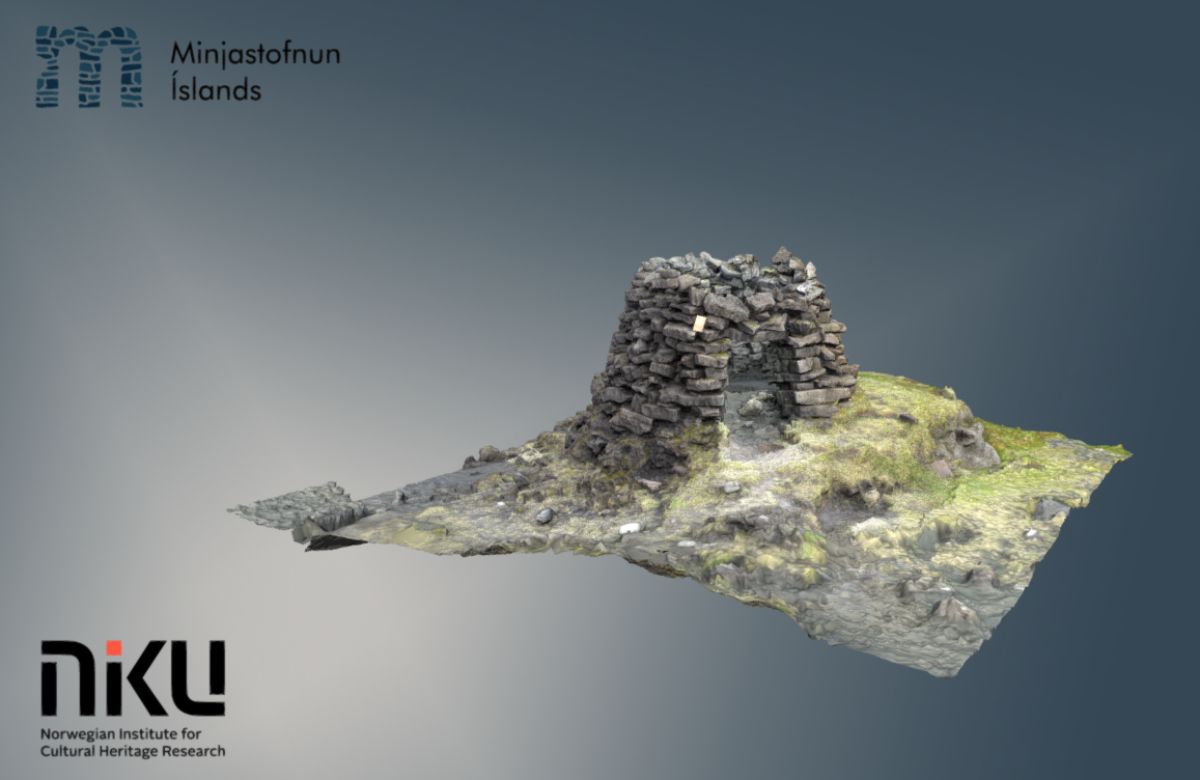
A fish shelter at Selatangar, an elongated fishing village that has been in use from the Middle Ages until the 19th century. Photo: NIKU / Minjastofnun Íslands
The Viking Herald also reached out to Sólrun Inga Traustadótir at the Minjastofnun Íslands, the Cultural Heritage Agency of Iceland, to get more information on recent developments.
TVH: At the end of 2021, there were worries that volcanic activity on the Reykjanes peninsula in Iceland poses a risk to several protected archaeological sites. What is the current situation?
SIT: The current situation is that specialists (geologists and geophysicists) believe that the volcanic eruption last year in Geldingadalir might be a start to a new series of eruptions on the Reykjanes peninsula. The last series occurred approx. eight hundred years ago and lasted around 30 years, it was called Reykjaneseldar (The Reykjanes Fires).
There are earthquakes every now and then in the area but not always at the same place. This indicates that magma is flowing below, and it is hard to know exactly when and where the magma will break through the surface.
TVH: Could you provide our readers with a brief summary of the follow-up work that has been carried out in Iceland since the end of last year?
SIT: We published a progress report about our work last year regarding the volcanic threat. Our survey department has been gathering all data we have on the sites in the endangered area, and there are a few places that need further basic documentation (drone and GPS) to gain a good overview of the archaeological sites, record information about their nature, number, form, and time period.
TVH: What are the most important techniques for conserving knowledge about endangered cultural landscapes, such as those in Iceland?
SIT: That is a hard question. It depends on the sites and how much is already known about them. The most important, fastest, and simplest way to conserve knowledge about archaeological sites, is basic archaeological field survey and recording.
Basic archaeological field survey entails mapping, digital drawings of sites/monuments, photography (ground and drone), and text descriptions. This enables us to quickly gather information about many sites in a relatively short time.
Other techniques like three-dimensional modeling and drone videos are also high on the list of techniques, as well as more intrusive methods like open excavation and test trenches, which are, of course, also of great importance since they provide more detailed information on the sites. However, they take more time and are sometimes not an option, for example, when dealing with natural disasters.
Models available online
The models have been prepared and are available online, with descriptions in Icelandic and English by the principal, Minjastofnun Íslands. They can be found HERE.
We get to provide readers with original coverage thanks to our loyal supporters. Do you enjoy our work? You can become a PATRON here or via our Patreon page. You'll get access to exclusive content and early access.
Feel free to reach out to discuss potential stories that may be in the public interest. You can reach us via email at [email protected] with the understanding that the information you provide might be used in our reporting and stories.